How Invisible Waves Have Changed the World
2024-04-25 [Petri]
It is understandable that electronic warfare is crucial on a modern battlefield.
Harassing civil aviation hundreds of kilometers away from the battlefield is not.
In my book, I go through the history of air navigation, from Non-Directional Beacons (NDBs) to VHF Omni Range (VOR) to Instrument Landing System (ILS).
VORs have been the backbone of route navigation for decades, and are familiar to every pilot. NDB antennas are still active every here and there, but they are at most a backup of a backup in the more advanced parts of the world. Pilots usually try navigation based on them just for curiosity reasons. And ILS landings are mandatory to get re-tested repeatedly by every instrument-rated pilot.
Both VORs and ILS systems are quite expensive to maintain, and as GPS is absolutely “free” from the users’ point of view, various new, and in practice, better, mechanisms have been designed to rely only on this new “service from space”.
The global drive in the past couple of years has been to leave just a country- or continent-wide network of high-power VORs for route navigation, and replace ILS with Area Navigation (RNAV) procedures for airports where the maintenance cost of ILS is not feasible in the light of incoming traffic volumes. RNAV can also serve as a faster approach alternative for busy airports.
Basic GPS accuracy is not good enough for such approaches, but having the Wide Area Augmentation System (WAAS) in the US and the European Geostationary Navigation Overlay System (EGNOS) in Europe increases the basic GPS accuracy down to three meters by providing a real-time correction signal from an additional geostationary satellite. This signal contains the necessary correction information that counteracts the continuously happening, random atmospheric deviation that inevitably degrades the base GPS signal.
Hence, in terms of technology, it is now much more economical to provide just a RNAV approach to a low-traffic airport, and thus decommission the earlier, expensive ILS system.
This was the “two birds with one stone” approach, based on new technology: you get increased usefulness and increased flexibility and precision, and hence increase the annual amount of successful landings during poor weather conditions at regional airports.
Generating RNAV approach essentially “from thin air” also expands the usefulness of small airports that formerly did not warrant having an ILS: these airports can now have RNAV approaches “for free”, and thus greatly improve their accessibility.
And naturally, for en-route navigation, GPS is a perfect “second opinion” even if your flight plan is based on VOR waypoints and you get your autopilot guidance from there: the moving map on your airplane shows whether you are on the planned track or not.
Finally, this also makes it possible to have full GPS based, point-to-point routing for Flight Plans, saving millions to airlines annually as they can replace the earlier, “jagged” VOR-to-VOR routes with “fly direct”, following just GPS.
So all this shift in relying more on GPS and other satellite navigation systems was nice and rosy and showing the power of enhanced technology, until Russia decided that attacking its sovereign neighbor would somehow make its position more prominent in the world.
The problem that has arisen from this conflict is that faking GPS signals is relatively low-tech excercise: their internal structure is public knowledge, and their signal strength is very, very low. The average altitude of a GPS satellite is roughly 20,000 km, and the transmitters are in space, relying on solar energy for their power, so the signal on the surface of the Earth is very weak.
Complicating your enemy’s navigation by any means is naturally part of any modern battleground strategy: you want to make your opponent’s life as difficult as possible, and precise navigation is one of the main aspects of effective, modern warfare.
But for some reason, Russia has decided that harassing regular civil aviation is somehow a good idea, even when they are flying thousands of kilometers away from the areas of conflict.
Case in point: the Baltic Sea.
Over 46,000 (!) flights so far have reported GPS issues over the Baltic Sea, and the main source of such interference has been traced back to Kaliningrad, which is a fully-detached enclave of Russia.
Thanks to multiple overlays and automatic system warnings, no life-threatening cases have yet happened, but these situations cause pointless extra workload for pilots while navigating through the densely populated European airspace.
At the time of writing this, in the early morning hours, FlightRadar24.com shows around 100 planes within the diamond of Helsinki-Vilnius-Berlin-Stockholm, as can be seen from the accompanying screenshot. It is very likely that many of these will report navigation problems even today.
Another “black spot” has been in Eastern Finland, all the way up to the border between Russia and Norway in the north. According to the Finnish Traficom statistics, the GPS disturbances went from 10 indicated cases in 2021 to 65 in 2022 to 230 in 2023.
The satellites that these systems rely upon are the same. The atmosphere through which the signals pass is the same. The navigation devices are on the average better every subsequent year.
So the only rational explanation for this degradation is Finland’s war-mongering neighbor in the east.
This is rather silly as all western military aircraft have multiple backups, all the way down to “pre-historical” Inertial Navigation Systems, and thus are pretty much immune to GPS jamming.
Therefore, as a result of this malicious behavior, the ones who suffer are just those normal folks traveling for example from Helsinki to Savonlinna, the famous site for annual opera festivals at the Olavinlinna Castle.
The reason why single destination like Savonlinna is more vulnerable for interference is is due to the fact that depending on the wind direction in Savonlinna, the only available approach in bad weather is an RNAV approach. The airport has ILS only at one end of the runway.
And if the GPS signal is not to be relied upon during poor weather conditions, the plane has no alternative than returning back to Helsinki.
Even on the battlefield in Ukraine, the effectiveness of the Russian jamming approach looks questionable:
Based on the seemingly endless stream of videos of First-Person View (FPV) drones hitting Russian military equipment and even individual soldiers, the ongoing Russian attempts of stopping Ukrainian drones with electronic warfare do not seem to be very effective.
Without knowing the intricate details, my guess is that the communication between the drone pilot and the FPV drone is using frequency hopping or some similar time-division multi-frequency method, which by default is resilient against most traditional interference modes.
For both personnel and material protection purposes, attempts to jam the actual drone control signal is the key issue, and as per the video material, seems to be mainly failing by the Russian troops.
GPS jamming still has its place: not getting the GPS position fix is relevant if the drone is being used as a targeting device, as the coordinates can’t be relied upon.
But even in those cases, if the pilot is familiar with the area and thus has positional awareness of the drone, the targeting references can be created manually with a map and satellite images from the area, eventually turning the visual cues to hardwired coordinates for missiles.
Therefore, in terms of GPS jamming, incoming GPS-guided missiles are the main jamming target. But as those have been designed for battleground use, they naturally take into account the possibility of fake signals, and have an inertia-based backup that is totally immune to interference: if the positional awareness starts to deviate between these two systems, the inertial system takes precedence.
Due to this, the target may be missed by a couple of tens of meters, and with some luck, not cause a total devastation at impact.
From the technology perspective, this is a cat-and-mouse game: the navigation equipment manufacturers can build multi-system redundancies, as we have not only the American GPS, but also the European Galileo and Chinese Baidu available globally. Jamming them all at the same time with the same kind of deviation becomes increasingly complicated as the number of redundant networks increase.
In theory, dynamically directional multiple antennas in the form of Phased Arrays could also be used, as the location of each satellite is known at all times. This would require an even stronger jamming signal, as the “listening ear” of the antenna can be attenuated against signals from the ground by directing it precisely towards the satellite.
As an alternative, there is also the Russian GLONASS system, but for apparent reasons, who would use that as a reference after all that has happened lately?
Actually, based on some downed Russian jets in Ukraine, even they had western-made civilian GPS units taped into the cockpit. So, for reasons unknown, Russians do not seem to rely on their own, very expensive satellite navigation network.
Whatever the Russian goals are in Ukraine in their attempt to subjugate a population of 40 million by a population of just 140 million, it is hard to see what, if anything, is gained by things like civil aviation harassment far, far away from the war zone.
Thousands of pilots have been tasked with totally unnecessary extra workload en-route, hundreds of normal passengers have been forced to re-plan their trips as their flights have had to turn back, and repeated news over this kind of malice by no means improves Russia’s esteem in the global eye.
But all that the rest of the world can do is work on even more resilient navigation technology.
As I wrote in my book, wars are great boosters for technological development:
Like the huge boost that Russia caused in the renewable energy space after their failed blackmail against the European Union, this GPS harassment is likely to generate major leaps in navigation resiliency.
Enhancements in this area will save both lives and money in the future.
Russia used to have multiple technological “firsts” during their Soviet Union era, but seems to have degraded into a global bully in its current, Russian Federation form.
The former superpower of Tsiolkovsky, Sputnik and Gagarin is spiraling into a global pariah status.
Permalink: https://bhoew.com/blog/en/156
Earlier entries
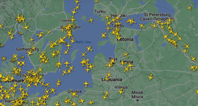
Hundreds of flights pass by the Baltic Sea daily [FlightRadar24.com]
You can purchase A Brief History of Everything Wireless: How Invisible Waves Have Changed the World from Springer or from Amazon US, CA, UK, BR, DE, ES, FR, IT, AU, IN, JP. For a more complete list of verified on-line bookstores by country, please click here.
Earlier entries:
You can purchase A Brief History of Everything Wireless: How Invisible Waves Have Changed the World from Springer or from Amazon US, CA, UK, BR, DE, ES, FR, IT, AU, IN, JP. For a more complete list of verified on-line bookstores by country, please click here.
PRIVACY STATEMENT AND CONTACT INFORMATION: we don't collect anything about your visits to this website: we think that your online history belongs to you alone. However, our blog comment section is managed by Disqus. Please read their privacy statement via this link. To contact the author directly, please costruct an email address from his first name and the name of this website. All product names, logos and brands are property of their respective owners and are used on this website for identification purposes only. © 2018 Petri Launiainen.